SEVERE WEATHER WARNING
Issued by MetService at 9:26 am Tuesday 30-Jul-2019
A period of heavy snow for southern and eastern parts of the South Island. Also,brief heavy rain possible about the Canterbury Plains below the snow level.
A cold southerly change is forecast to spread north across the South Island during today and into Wednesday, bringing snow down to 200 metres in some places.A period of significant snowfall is expected above 400 metres about the Kaikoura Ranges, the Canterbury High Country and foothills, and also northern parts of Central Otago, and a Heavy Snow Warning (Orange) is now in force for these areas.Please note, Heavy Snow Watches remain in effect for the remainder of Central Otago, the Southern Lakes, Fiordland and inland parts of Clutha and Southland.
In addition, a period of heavy rain is expected below the snow level about the the Canterbury Plains including Christchurch, and a Heavy Rain Watch is now in force for this area.
People are advised to keep up to date with the latest forecasts in case any changes are made to the current Watches or Warnings, or other areas are added.
===========================
HEAVY SNOW WARNING - ORANGE
===========================
Heavy snow may disrupt travel in affected areas and could damage trees and powerlines. Cold conditions may cause stress for livestock.
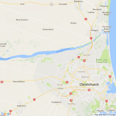
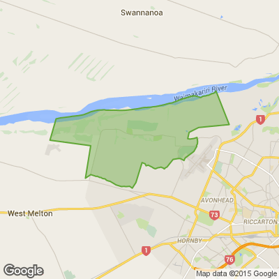
Area: Marlborough south of Ward including the Kaikoura ranges, also the Canterbury High Country and Plains above 200 metres north of the Waimakariri River
Valid: 12 hours from 3:00 am to 3:00 pm Wednesday
Forecast: Snow is expected to fall to about 200 metres during this time. Expect 15 to 20cm of snow to accumulate about and above 400 metres, with even deeper snow expected at higher levels.
Change note: This area has now been upgraded to a Warning (Orange).
Area: Canterbury High Country and Plains above 200 metres from the Waimakariri River southwards, and Central Otago north of Omakau
Valid: 14 hours from 6:00 pm Tuesday to 8:00 am Wednesday
Forecast: Snow is expected to fall to about 200 metres during this time. Expect 15 to 20cm of snow to accumulate about and above 400 metres, with even deeper snow expected at higher levels.
Change note: Area extended north to the Waimakariri River, previously the Rakaia River.
An update for severe weather will be issued by: 9:00 pm Tuesday
30-Jul-2019
Poll: Do you set New Year’s resolutions?
🎉 2026 is almost here!
We’re curious ... how do you welcome it?
Do you set resolutions, follow special traditions, or just go with the flow?

-
10.5% Yes! New Year, New Me
-
20.2% Yes - but I rarely stick to them
-
69.3% Nah - not for me
Scam Alert: Fake information regarding December Bonuses from MSD
The Ministry of Social Development is reporting that fake information is circulating about new ‘December bonuses’ or ‘benefit increases’
If you get suspicious communication, please contact Netsafe.

Today’s Mind-Bender is the Last of the Year! Can You Guess It Before Everyone Else? 🌟🎁🌲
I dance in the sky with green and gold, a spectacle few are lucky to behold; I’m best seen in the south, a celestial sight—what am I, lighting up the New Zealand night?
Do you think you know the answer? Simply 'Like' this post and we'll post the answer in the comments below at 2pm on the day!
Want to stop seeing these in your newsfeed? No worries! Simply head here and click once on the Following button.

 Loading…