Resident Question - DMAPS Flight Path
✈️ We've received a question from a resident under the DMAPS flight path who used Flightradar and Webtrak to challenge the altitude data in Wellington Airport's consultation documents.
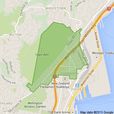
We can confirm (📸 see the pic in the comments) that flights have been recorded at altitudes below 3,000 feet over Khandallah and below 4,000 feet over Johnsonville.
The terrain in these areas varies significantly: 🌳 Khandallah is 880 feet, 🌄 Broadmeadows is 984 feet, 🏘️ Johnsonville is 495 feet, 🏞️ Horokiwi is 820 feet, 🌊 Korokoro is 135 feet, and 🏡 Newlands is 453 feet.
So, while the document doesn’t explicitly state it, flights are flying low and close to the suburbs under the current DMAPS flight path. 🌍 Sea level comparisons aren’t an accurate representation because the topography of our Wellington suburbs varies! 🌿
Find out more at planesensewellington.com

Poll: Do you set New Year’s resolutions?
🎉 2026 is almost here!
We’re curious ... how do you welcome it?
Do you set resolutions, follow special traditions, or just go with the flow?

-
10.5% Yes! New Year, New Me
-
19.7% Yes - but I rarely stick to them
-
69.7% Nah - not for me
Scam Alert: Fake information regarding December Bonuses from MSD
The Ministry of Social Development is reporting that fake information is circulating about new ‘December bonuses’ or ‘benefit increases’
If you get suspicious communication, please contact Netsafe.

🎉The Riddler wants to hear from you 🫵
🧩 Got a riddle that can stump your Neighbourly community? Share your brain teasers with us and watch your neighbours scratch their heads 😕🤔❓
Send us your tricky puzzles!

 Loading…